

Safe Spaces for Women to be Physically Active in Greater Noida City, India
Abstract
Introduction
Women in urban India have low levels of physical activity, and the lack of safe spaces to be physically active is likely an important factor. The objectives were to develop a spatial database of areas and facilities in order to assess conduciveness to physical activity in Greater Noida, to assess the safety and usability of roadways and community parks in this area, and to complement these data with the first-hand impressions and viewpoints of women in the city.
Methods
For 10 sectors of Greater Noida City, we used a mixed-methods approach to assess areas conducive to physical activity with geographic information systems mapping techniques, and examined the safety and usability of roadways and community parks with modified road walkability and park usability field surveys. Ten focus groups with women in six of the sectors elicited their viewpoints on the availability of safe spaces.
Results
Walkability and safety of roads was poor, with the larger primary roads being particularly difficult for pedestrians to cross. In sectors of low socioeconomic status, walkability of roads and availability of community parks were lower than in other sectors. Wide variation of community park usability existed within sectors, with a notable absence of amenities such as bathrooms. Focus group sessions revealed that fear of personal safety and of attack from men prevented women from engaging in physical activity in public spaces.
Conclusions
In the rapidly urbanizing Greater Noida, walkable roadways and community parks with basic amenities are lacking, and may contribute to the low level of physical activity in women in urban India. Further, a fear for personal safety hinders women from engaging in physical activity in public spaces. As India continues to urbanize, a greater focus on the improved usability and increased safety of roadways and parks will be necessary to increase population physical activity.
Keywords
Physical activity, Women, Community assessment, India
Introduction
Cardiovascular disease (CVD) is the leading cause of mortality, accounting for 31% of global deaths in 2012 [1]. Three-fourths of these deaths occurred in low- and middle-income countries, where the rate of CVD continues to rise. In India, rapid urbanization has led to a significant urban/rural gradient with regard to CVD risk factors and mortality [2]. While rural men have the highest prevalence of tobacco smoking, other key risk factors such as hypertension, hyperlipidemia, obesity, diabetes, and metabolic syndrome are more prevalent in urban women and men. Each of these urban risk factors, and associated cardiovascular and all-cause mortality, can be reduced by increased levels of physical activity [3].
Despite this, few Indians actually engage in regular recreational physical activity [4], and urban women in particular have very low levels of physical activity [5]. There may be several reasons for this, but the availability of safe spaces to exercise appears to be a major component [6]. This is of particular relevance to Greater Noida City: as the city continues to transform into a large urban center over the coming years, city planners have a unique opportunity to address and reduce environmental barriers to a healthy lifestyle for its inhabitants, and for its women in particular.
We therefore aimed to systematically evaluate the availability of safe spaces to be physically active in Greater Noida City, using geographical information systems (GIS) techniques, as well as qualitative focus group sessions with female residents. Specifically, our objectives were to develop a spatial database of areas and facilities in order to assess conduciveness to physical activity in Greater Noida, to assess the safety and usability of roadways and community parks in this area, and to complement these data with the first-hand impressions and viewpoints of women in the city.
Methods
Site and Sector Selection
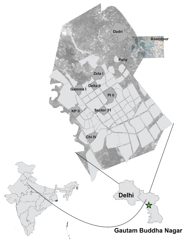
Greater Noida City is located in Gautam Buddha Nagar district of Uttar Pradesh state. Adjacent to Delhi, Greater Noida is actively being built as a city to accommodate spillover from Noida city, which itself accommodated spillover from Delhi. Greater Noida provides a model case of transition from rural to urban where villages and surrounding land are being progressively acquired for planned urbanization [7]. The population, according to the 2011 census, is over 102,000 [8]. This includes an urban population, consisting largely of people who have migrated for technology-related work, and a native village population who practice agriculture, but who are experiencing changes in their livelihood with the urban transition.
The city has been divided into 61 sectors by the municipal government based on a development plan put in place in 2001 [5]. Using Worldview 2 multispectral satellite data, each of these sectors was categorized into standard land-use categories [9]: Urban Residential, Industrial, Roads, Vegetation, Cropland, and Water bodies. Each sector was also categorized according to socioeconomic status (SES). The SES of each sector was determined by housing type in the sector, professions of sector residents, and amenities owned. Using an online random number generator, ten sectors were randomly selected to be included in this study. Two selected sectors were still under development and therefore did not have a significant residential population. They were therefore replaced by two adjacent alternate sectors of similar SES level.
GIS mapping
Geographic information systems (GIS) extends the utility of maps by allowing users to interact with and query maps, capture information from various sources such as satellite images, and overlay information to create a comprehensive tool. Satellite images were acquired from Apollo Mapping Inc. ArcGIS software was used for mapping and spatial analysis. Digital classification of satellite data was verified by trained research assistants who visited areas to confirm image classification. Finally, archived maps and planning maps prepared by local authorities were also used for verification of GIS data.
Road evaluation
In each of the 10 chosen sectors, road data was digitized using Worldview-2 satellite imagery (Digital Globe, Inc; Westminster, CO, USA). Each road was divided into individual segments. For example, a section of road between two cross-roads was considered a single road segment, the unit of observation. Further, each road segment was classified into 4 categories. A primary road was one running between sectors with multiple lanes. A secondary road joined residential roads to primary roads. Residential roads were smaller roads through residential areas. The final road category was roundabouts.
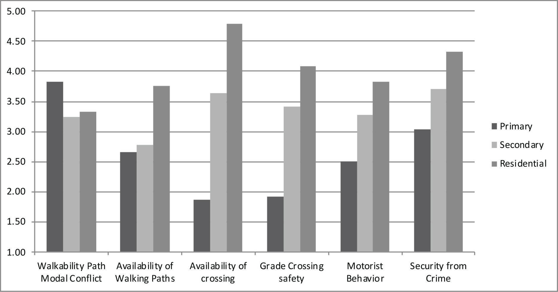
Due to the large number of roads, approximately 30% of the road segments in each road category were randomly selected for field survey in each sector. A walkability assessment tool was used to assess each of the selected road segments. This tool was based on the walkability assessment tool used by the Clean Air Initiative for Asian Cities Center [10], which has been adapted for the Asian context from the Global Walkability Index [11]. The Global Walkability Index was developed by the World Bank to assist city planners in improving the pedestrian environment. For the purposes of our analysis, we used 7 of the original 9 factors from the Clean Air Initiative for Asian Cities Center tool that are relevant for the Greater Noida area, and for the issue of safety specifically (modified walkability assessment tool for Greater Noida available from authors upon request). The 7 factors included in this walkability assessment tool are: Walkability Path Modal Conflict, Availability of Walking Paths, Availability of Crossings, Grade Crossing Safety, Motorist behavior, Amenities, and Security from Crime. The two factors not included were Obstructions, which were considered to be an issue of convenience rather than safety, and Disability Infrastructure, which addressed the safety of only a small minority of the overall population.
Field observations of the selected road segments were carried out by two graduate students from the Department of Civil Engineering at Shiv Nadar University. They were trained to rank each of the seven factors in our adapted walkability assessment tool from 1 to 5, with 1 being poor for pedestrians, and 5 being ideal. For example, a score of 1 for Walkability Path Modal Conflict indicates that there is significant conflict between different modes of transportation (i.e. car, bicycle, rickshaw, pedestrians) for a given segment, while a score of 5 indicates no such conflict. Appendix 1 gives visual representation of different rankings for Availability of Walking Paths. Between 10 AM and 1 PM on weekdays, the field observers went to the chosen road segments in a given sector and completed a single data collection form for each segment. The data were then entered into Microsoft Excel 2010, and mean values were calculated for each factor across road types and across sectors. The data were then transferred to the GIS mapping system for graphical display.
Community park evaluation
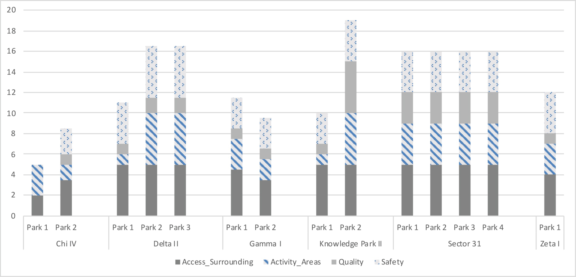
Community parks within each of the 10 chosen sectors were identified by satellite imagery, and those that were accessible to the public were assessed by field observers. The Community park audit tool (CPAT), a validated tool developed by the Kansas Parks and Physical Activity Project to assess the potential to promote physical activity, was modified for the Indian context [12]. Specifically, each of the main content areas of the CPAT was retained, but questions not directly related to personal safety or which were deemed to be less relevant for urban India were omitted. Instead, the modified version focused on "access and surrounding neighborhood" (i.e. ease of access, sidewalks bordering the park, and well-lit areas in the neighborhood surrounding the park), "park activity areas" (i.e. availability of a playground, walking trail, fitness equipment, and green spaces to exercise), "park quality" (i.e. availability of public restrooms, drinking water fountains, or shady areas), and "park safety" (i.e. lights in the park, presence of a park monitor, graffiti, excessive litter and animal waste, or threatening persons). Each parameter was scored from 1 to 5, with 1 being poor and 5 being ideal. Appendix 2 shows the modified version of the CPAT that was used in this study. Appendix 3 gives visual representation of different rankings for Availability of Park Activity Areas.
Field observations of community parks were also carried out by two research assistants trained in the use of the modified park assessment tool, and between 10 AM and 1 PM on weekdays, they went to the community parks in the chosen sectors and completed a single data collection form for each park. The data were then entered into Microsoft Excel 2010 and mean values for each category for the parks in each sector were calculated. Finally, the data were transferred to the GIS mapping system for graphical display. For purposes of analyses, each of the 10 sectors was categorized by SES into lower (2 sectors), middle (6 sectors), or upper SES (2 sectors). Lower SES included small housing sizes (≤ 500 sq. ft.), two wheeler vehicle, and blue collar jobs; middle SES was marked by medium housing (500-1000 sq. ft.), one four wheeler vehicle, and white collar jobs; and upper SES included independent villas or duplexes, more than one vehicle and a business job.
Focus group discussions
Focus group sessions were conducted to elicit the views of local women on the availability of safe spaces to be physically active in the Greater Noida Area. A total of ten sessions were conducted in each of the previously identified sectors, and were purposefully selected to include women from a range of socioeconomic backgrounds. Each session included 8-10 participants and 2 facilitators, and was conducted in Hindi. The participants were recruited through a contact person (resident of the same locality), and the sessions were held at community centers. The facilitators were a graduate student and a Professor in the Department of English at Shiv Nadar University, both of whom had been trained in the conduct of focus groups. The guiding questions for the discussions are outlined in Table 1. The discussions were recorded using Sony SO-ICD-PX240 4 GB Voice Recorder. The focus groups were not transcribed and translated into English due to limited resources. The Professor listened to each audio-recording and identified the key recurring themes across sessions.
Results
The 10 selected sectors and their characteristics are shown in Table 2, and their locations within the Greater Noida Area are shown in Figure 1.
Road evaluation
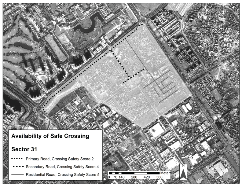
In aggregate, across all 10 sectors, none of the 7 parameters assessed were deemed "ideal" (i.e. highest score of 5) for primary, secondary, or residential roads (Figure 2). Overall, the smaller residential roads had the best scores and the larger primary roads the worst scores, with the exception of the parameter "path modal conflict", for which primary roads scored better than residential roads. Primary roads scored the worst (score ≤ 2) for "availability of crossing" and "grade crossing safety", indicating that the availability of safe paths for pedestrians to cross primary roads is lacking. Figure 3 gives an example of the roadways in Sector 31 by road type and by score for one of the 7 parameters assessed, namely "availability of crossing".
When comparing roads in sectors with different socioeconomic status (low, middle, upper), the following parameters worsened with decreasing SES: modal conflict, availability of walking paths and amenities. The "availability of crossing", "grade crossing safety", "motorist behavior", and "security from crime" did not appear to vary by SES level (data not shown).
Community park evaluation
A total of 14 parks were surveyed across 10 sectors. Overall, no park surveyed obtained the best score for all 4 parameters. The parameter with the worst scores across the sectors was "park quality", i.e. the availability of basic amenities such as public restrooms, drinking water fountains, trash cans, and shady areas [mean score = 1.8, ± 0.8]. The parameter with the best scores across the sectors was "access and surrounding neighborhood", i.e. ease of access to the park, sidewalks bordering the park, and well-lit areas in the neighborhood surrounding the park [mean score = 4.5 ± 0.8].
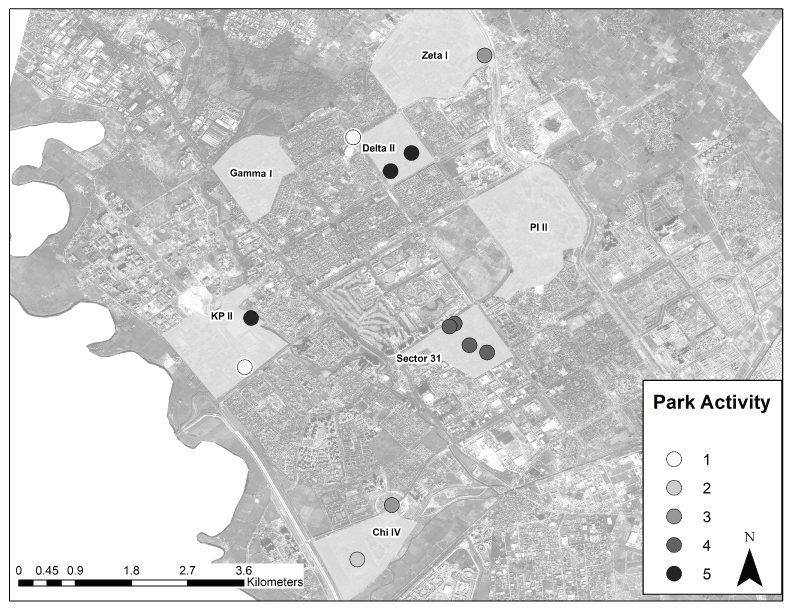
There was again wide variation across the sectors, as shown in Figure 4 for "park activity areas". Similarly, there was also variation within each sector, as shown in Figure 5. Of note, there were no community parks at all in the 2 sectors in the low SES group.
Focus group discussions
Analysis of the focus group discussions yielded two primary themes related to physical activity: the known benefits of exercise, and personal safety as a barrier to exercise. Most participants were aware of the health benefits of physical activity, and television and radio broadcasts contributed greatly to this awareness. Many admitted to feeling self-conscious about jogging/running, though they were aware of the potential health benefits.
In all but the two poorest sectors, the participants focused heavily on fear of personal safety as a major barrier to physical activity. Specifically, they were concerned about possible attack from men, which hindered them from exercising outside, particularly outside their enclosed housing compounds. They commented on the lack of police or security monitoring in parks and on roads as a major problem, along with the fact that few people are outside in the early morning or late evening, when most of the women would have time to exercise. Though only a total of 3 participants had personally experienced a threat to their safety while outside, many others reported that their fear was due to hearing stories of or from other women who had been physically threatened.
Discussion
Despite the known benefits of physical activity in reducing cardiovascular disease risk, very few women in urban India participate in regular recreational physical activity, though the reasons for this may be several. One possible important reason is the lack of available safe spaces for women to exercise, but little has been published on this topic [6]. We have demonstrated the feasibility of a mixed-methods approach to address this gap in knowledge. We show that available roads and community parks are not conducive to physical activity. Many of the large roads lack safe pedestrian crossings, and "modal conflict" and "availability of walking paths" worsens with decreasing SES. While there was wide variation across and within each sector surveyed, overall park usability was low. Of special concern, the poorer areas had no community parks at all, and even those in the middle and upper SES sectors were lacking in amenities such as public bathrooms.
A large amount of data support the importance of walkable neighborhoods in promoting physical activity among local citizens. A recent meta-analysis including studies performed in China and Japan, found that higher neighborhood walkability is associated with higher levels of biosensor-assessed walking in adults [13]. Further, in some communities in the U.S., neighborhood walkability appears to have a greater impact on women's decision to exercise, compared with that of men [14]. However, information about road walkability and availability of community parks in India is very limited. Adlakha and colleagues surveyed 370 individuals in Chennai, India about the role of the built environment in facilitating physical activity, and found complex relationships between the built environment, physical activity in the context of traveling from one destination to another, and physical activity for the purpose of recreation [15]. However, we are not aware of any prior studies that have surveyed elements of the built environment in India, such as roads and community parks, and assessed walkability, quality, and safety. Our study therefore adds to the literature by demonstrating that roads in the Greater Noida Area are generally not conducive to walking, and that community parks are either of relatively poor quality or are not present at all in poorer areas. Further, our mixed methods approach has adapted validated methodology for the Indian context to address this important issue.
The most important finding from the focus groups is that, beyond the quality and availability of spaces to exercise in the Greater Noida Area, women of middle and upper SES are very hesitant to be physically active outside the home due to concerns of safety threats from men. These concerns are likely heightened by multiple recent high-profile cases of violence against women in nearby Delhi [16], and an increase in reporting of rape crimes to the police over the past several years in India [17]. According to the National Crime Records Bureau, 36,735 cases of rape were reported in 2014 [18], and this is likely a gross underestimate of the occurrence of gender-based violence, as only an estimated 2% of such cases of violence are actually reported to the police in India [19]. In the context of such common violence against women, the fear of the women that we interviewed to perform physical activity outside is understandable. Beyond developing more walkable roads and usable community parks, city planners and local authorities in India will need to focus on safety measures for women to actually use these resources, such as increased police presence or emergency stations from which phone calls can be made.
Strengths of this study include the integration of field assessments with existing data using sophisticated GIS mapping techniques, and then supplementing these findings with qualitative data from women in these same communities. We demonstrate the feasibility and usefulness of combining GIS mapping with public health assessments, and integrating the results from these with real-world views of local women from a variety of SES backgrounds. However, our study also has several limitations. First, while road segments were randomly selected, a number of parks identified on satellite imaging were not accessible to the public. Those parks that were assessed were still selected to be representative of the overall sector and the socioeconomic diversity of the area. Second, we did not assess inter-observer variability in the field observations. Finally, the views of the focus group participants may not be representative of all women in the Greater Noida Area.
Our study points to several areas of future research and opportunities for health advocacy. Although Greater Noida is promoted as a "planned city" with a focus on the health of individuals, we believe that the needs of residents to have safe areas to participate in physical activity have not been adequately addressed. Government officials and city planners need to be made aware of this situation, so that they can incorporate safe, usable spaces to exercise in the next phase of city planning. For example, large roads need safer crossing paths for pedestrians, and areas of lower SES need community parks. Those parks that already exist in areas of higher SES need basic amenities such as public restrooms, drinking water fountains, trash cans, and shady areas. Perhaps most importantly, the safety of women using these spaces needs to be made a priority. Future city plans need to incorporate solutions for the concerns raised by women regarding their personal safety.
Conclusion
In rapidly urbanizing Greater Noida, roadways which are safe to cross and community parks with basic amenities are lacking, and this may contribute to the low exercise levels observed in women and increasing CVD levels in urban India. Further, women appear to have a strong fear for their personal safety in public spaces. As India continues to urbanize, a greater focus on the improved usability of roadways and parks and on safety measures in public spaces is necessary to enable greater population physical activity.
References
- http://www.who.int/mediacentre/factsheets/fs317/en/.
- Gupta R, Guptha S, Sharma KK, et al. (2012) Regional variations in cardiovascular risk factors in India: India heart watch. World J Cardiol 4: 112-120.
- Warburton DE, Nicol CW, Bredin SS (2006) Health benefits of physical activity: the evidence. CMAJ 174: 801-809.
- Anjana RM, Pradeepa R, Das AK, et al. (2014) Physical activity and inactivity patterns in India - results from the ICMR-INDIAB study (Phase-1) [ICMR-INDIAB-5]. Int J Behav Nutr Phys Act 11: 26.
- Pandey RM, Gupta R, Misra A, et al. (2013) Determinants of urban-rural differences in cardiovascular risk factors in middle-aged women in India: A cross-sectional study. Int J Cardiol 163: 157-162.
- Anjana RM, Ranjani H, Unnikrishnan R, et al. (2015) Exercise patterns and behaviour in Asian Indians: data from the baseline survey of the Diabetes Community Lifestyle Improvement Program (D-CLIP). Diabetes Res Clin Pract 107: 77-84.
- Aradhak P (2014) Noida, Gr Noida may become India's first smart cities. Times of India.
- (2011) Greater Noida City Census 2011 Data.
- Anderson JRH, Roach JT, Witmer RE (1976) A Land Use and Land Cover Classification System for Use with Remote Sensor Data.
- (2011) Walkability in Indian Cities.
- Krambeck H (2006) The Global Walkability Index.
- Kaczynski AT, Stanis SA, Besenyi GM (2012) Development and testing of a community stakeholder park audit tool. Am J Prev Med 42: 242-249.
- Hajna S, Ross NA, Brazeau AS, et al. (2015) Associations between neighbourhood walkability and daily steps in adults: A systematic review and meta-analysis. BMC Public Health 15: 768.
- Richardson AS, Troxel WM, Ghosh-Dastidar MB, et al. (2017) One size doesn't fit all: cross-sectional associations between neighborhood walkability, crime and physical activity depends on age and sex of residents. BMC Public Health 17: 97.
- Adlakha D, Hipp JA, Brownson RC, et al. (2017) "Can we walk?" environmental supports for physical activity in India. Prev Med.
- Phillips M, Mostofian F, Jetly R, et al. (2015) Media coverage of violence against women in India: a systematic study of a high profile rape case. BMC Womens Health 15: 3.
- Raj A, McDougal L (2014) Sexual violence and rape in India. Lancet 383: 865.
- NCRB (2014) Statistical Publications - Chapter 5: Crimes against women.
- Palermo T, Bleck J, Peterman A (2014) Tip of the iceberg: reporting and gender-based violence in developing countries. Am J Epidemiol 179: 602-612.
Corresponding Author
Neha J Pagidipati, MD MPH, Duke Clinical Research Institute, Duke University School of Medicine, PO Box 17969, Durham, North Carolina, USA.
Copyright
© 2018 Pagidipati NJ, et al. This is an open-access article distributed under the terms of the Creative Commons Attribution License, which permits unrestricted use, distribution, and reproduction in any medium, provided the original author and source are credited.