

Maritime Orbital Strategic Superiority using Artificial Intelligence Capacity Building (MOS2AIC-B)
Abstract
This paper investigates the effect of Artificial Intelligence (AI) using small satellites (< 1 kgr) in order to provide the framework for a governmental maritime superiority orbital system. The study is a step forward to fill the gap in existing very few global scale research actions, on how very small satellites can increase their orbital performance through artificial intelligence. To date, micro space-based solutions offer a new paradigm in the maritime domain. These entail formations of several low orbit cube satellites and picosatellites collect and download data in five to seven-minute intervals. Small satellites could work as "space agents", under the notion of a distributed learning system, which would encompass the ability to perform numerous critical functions on orbit, without human intervention, preserving in parallel physical and cyber parameters of the system itself. Cubesat role in maritime network support is to quickly morph a surface orbital mesh system including characteristics of cognitive behavior. Based on almost infinite parameter inputs the so-called "orbital artificial intelligent" system could prioritize tasks and feed critical information as inputs to ground, whereas at the same time materialize decisions in accordance with self-training methods prior and after going to orbit.
Statement of the Problem
This proposal investigates the effect of Artificial Intelligence (AI) using small satellites (< 1 kgr) in order to provide the framework for a governmental maritime superiority orbital system.
The study is a step forward to fill the gap in existing very few global scale research actions, on how very small satellites can increase their orbital performance through artificial intelligence [1]. To date, microspace based solutions offer a new paradigm in the maritime domain. These entail formations of several low orbit cube satellites and picosatellites collect and download data in five to seven minute intervals [2]. Small satellites could work as "space agents", under the notion of a distributed learning system [3], which would encompass the ability to perform numerous critical functions on orbit, without human intervention, preserving in parallel physical and cyber parameters of the system itself. Cubesat role in maritime network support is to quickly morph a surface orbital mesh system including characteristics of cognitive behavior [2].
Today, systems work as "decisive agents" with some or continuous human intervention from the ground. Critical information though during operations may be lost taking into account that when a human intervenes with the system no spherical and holistic knowledge of the ambient operations is well perceived. Humans act only utilizing information on the specific time frame whereas an artificial intelligence system could work collecting and analyzing inputs from various sources on orbit that a human does not have the physical and mental ability to execute. Based on almost infinite parameter inputs the so-called "orbital artificial intelligent" system could prioritize tasks and feed critical information as inputs to ground, whereas at the same time materialize decisions in accordance with self-training methods prior and after going to orbit.
When referring to maritime superiority one understands that all possible parameters happening in or around the maritime environment must be analyzed with an autonomous decision making super system where, based on artificial intelligence contemporary methods, superiority will be applied with ability to solve anomalous conflicts that may arise through accrued patterns.
Background and relevance to previous work
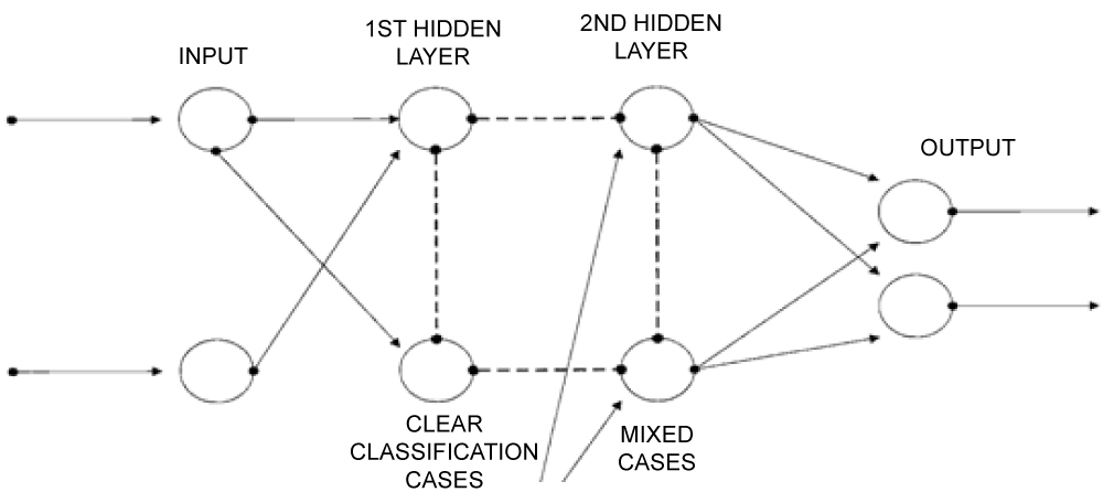
Hugin has been reported as the first microsatellite to implement basic artificial intelligence [4] on orbit. However, the technology at that time was not ready to perform such tasks, not to mention that satellites where in the scale of 100 kgrs. Years later, with GPS evolution [5] an effort was made to create a mesh network link among GPS satellites and lower earth orbiting satellites, aiming to transfer accurate meteorological data to Earth. This application though was only a simple link among satellites, without any nugget of decisive orbital control function. Later enough, [6] imported the idea of mesh network into a celestial system, which was implemented through CENETIX lab [7] trying to investigate picosatellite support in maritime interdiction operations. At the same time, European Space Agency's advance concept team, referred to a similar work concept [8]. A little bit later [9] and [10] tried to create the first generic algorithm and analyze satellite events. In parallel, conflicting knowledge management was introduced [11] in an artificial intelligence ambient environment. From that point on, research in NPS continued [12] with the first ever report to a picosatellite simulated celestial network. Based on case base reasoning and adaptive working mechanisms [13] a maritime interdiction operations network simulated with satellite agents working as facilitators using collaborative feedback controls and mechanisms with layers of different decision points working as Service Level Management nodes (Figure 1). The idea evolved [14] to application of real picosatellites into a maritime security operation (counter piracy) upgrading the initial notion from tactical to operational level. Three real picosatellites were designed and created (Lambdasat and Tubesat type) where one of them launched in 2014 and participated in a mission successfully measuring communication protocols through very low earth orbiting satellites. Of course, no artificial intelligence methods were implied, but it was the first successful step to implement a very small satellite in a real maritime security mission and measure its performance. Today, [15] artificial intelligence is being conducted primarily on ground stations analyzing satellite imagery for commercial applications. Big Data Analysis algorithms are being also used for acquiring predictive patterns through satellite imagery, applying an initial sense of artificial intelligence [16,17]. However, no small satellites have worked up to now using artificial intelligence techniques on orbit and taking governmental maritime superiority to a strategic level.
Work performed in NPS's CENETIX lab, from 2011, is now mature to move a step forward and apply AI techniques to small satellites aiming to extent maritime superiority using robotic principles. Research's' ultimate goal is to create a self-trained capable orbital system, which during time advent, will have the capability and capacity to execute complex event processing missions that humans would have difficulty to perform correctly and accurately.
General methodology
Notions, such as distributed artificial intelligence, enhanced situation self-system awareness, decision support for system design can be applied to a holistic global maritime system defining in an accurate way behaviors into the dynamical system which each agent will follow utilizing some type of hierarchy (Figure 1). System critical thinking and ethical decision making are only two of the numerous parameters that the system design needs to maintain in order to support maritime superiority principles on a global scale. This environment should be stemming and be in absolute harmony with applied Maritime Policy and Strategy directions a government is willing to follow.
Adding to the above and moving the cubit forward, one should explore conflicting knowledge in artificial intelligence environments, as well as complex distributed multi agent scenarios. Ambient intelligence is another uncharted up to now research area as well as conflict resolution management that will be studied. Some of the main characteristics that the system needs to maintain are being referred below [11]:
1. Embedded environment: Users do not need to be concerned with their operation.
2. Context-aware: They are able to recognize the user and the situation.
3. Personalized: Able serve different users according to their own needs.
4. Adaptive: They can change in response to the environment and user's actions.
5. Anticipatory: Understand the user's needs and act upon them proactively and not just in response to user's request.
6. Predictive: Ultimate goal for a system is during AI process to be capable of predicting the future or not leaving the system undisturbed to alerts.
In order to achieve the above aim, one must create ways of knowledge propagation ensuring well preservation of maritime superiority at all possible levels (tactical to strategic). Scalability, propagation and modularization needs to be further exploited using a startup point of reasoning and ontologies and determining in the initial level through machine learning unusual or predictive problems. The so-called social and ethical component needs in tacit to be taken into account. Interagent communication will be direct, indirect and unlimited in range and all possible interlinks and paths will be thoroughly tested.
Our research goal is to apply network centric artificial intelligence to a system of networks and design new techniques supporting real maritime operations, so as to increase and safeguard global maritime superiority. By creating a common operational environment and combining actual field experiments with operations under unique simulations, interacting with a virtual environment, we hope to create the baseline for artificial intelligence through orbital nodes into maritime superiority.
To support this research, we plan to:
1. Create and Design a functional Orbital Development Plan (Qualitative Analysis).
2. Execute a deep literature survey for artificial intelligence methods and apply those into orbital (picosatellite) maritime superiority environment (very few information available as of today).
3. Create a mathematical model to describe the initial system (starting from regression analysis methods).
4. Design an Artificial Neural Network simulating in orbit movements and exchange of Knowledge (initial point will be this of Figure 1).
5. Create Own Software Diagnosis Tool (through Matlab) to have continuous capability of upgrading the system, following each iterative process and adding more agents where needed.
6. Create a space orbital testbed (air table environment with 4 to 6 picosatellites) to load them with an initial artificial intelligent system and start experimenting new techniques. Design and Create a set of experiments to execute semi-simulated real operations. To further enhance this integrate "Technion Satellite Lab" (Haifa University) into the project.
7. Implement semi simulated sessions in lab experiments utilizing Matlab/Simulink/Satellite Tool Kit (STK)/Qualnet and Artificial Neural Network relevant software suites in order to simulate real operations.
8. Simulate a real maritime operation on the testbed, acquire results and implement these to CENETIX field experiments linking Naval Postgraduate School's testbed with NATO Maritime Center in Souda Bay (NMIOTC - www.nmiotc.gr) along with the University of the Aegean Innovation Lab, in order to validate results.
9. Test the system in orbit - Launch the picosatellites and measure network key performance parameters.
10. Investigate new patterns by using digital farming techniques and data aggregation methods.
11. Train the system to work holistically and without human intervention from A to Z.
12. Propose specific inputs and outputs that a system must encompass in order to sustain effectively a real maritime operation, proving that it can provide to government strategic maritime superiority.
Some of the real scenarios that can be applied throughout the research are:
1. Use of Big Data Analytics from space imagery intelligent methods (hardware and software) to produce patterns and increase maritime security awareness.
2. Measure global maritime commons patterns using AI.
3. Measure global shipping trends by satellite imagery, AIS and non AIS data.
4. Use AI in order to formulate governmental use of satellite imagery through analysis, countering illegal acts and increasing security in all its aspects. Measure illegal immigration population shifts with satellite data and associated movement of ships/boats.
5. Secure littoral operations and offshore platforms via orbital AI.
6. Employ micropropulsion systems to efficiently use power resources onboard and increase system lifetime, thus increase superiority and decrease associative costs.
7. Employ fractional and scalable measurements comparing to old big traditional systems (System Trade study).
To support the above a 3-year study will be efficient to design (6 months), simulate (9 months) and prepare (3 months), launch (3 months) and test the system in orbit (9 months). Finally analyze and provide final results (6 months). The overall length of the project should not extend a 3 year timeframe.
New or unusual methods
Following the above brief analysis, we believe that successful conduction of experiments with Tubesat and Lambasat picosatellites in the last three years has taken us to the point where it appears that a future model exists with the capability to fulfill orbital tasks for maritime superiority.
Ad hoc networks have been around for many years trying to make our lives simpler but dynamic. However, their fitting into our traditional environment has revealed science gaps when the application theory comes to reality. These gaps are usually very difficult to overcome and the primary reason is human behavior and interaction. It is evident that people have limits in their capabilities especially on how they react to decision making and to their base knowledge of things [13]. Modern theory of information flow [13], assisting by AI, will eventually overcome inherent limitations of traditional thinking.
Picosatellites experiments revealed those limitations and lead us to record chasms, advantages and disadvantages from the application of orbital nodes to an ad hoc network. The proposed visualized model acting as an artificial intelligence network, with critical dynamic capabilities and parameters, must be rigorous, agile, flexible and transgenic. No one up to now has ever tried to apply an artificial network algorithm to tactical through strategic maritime superiority safeguarding maritime governance.
Expected results, significance and application
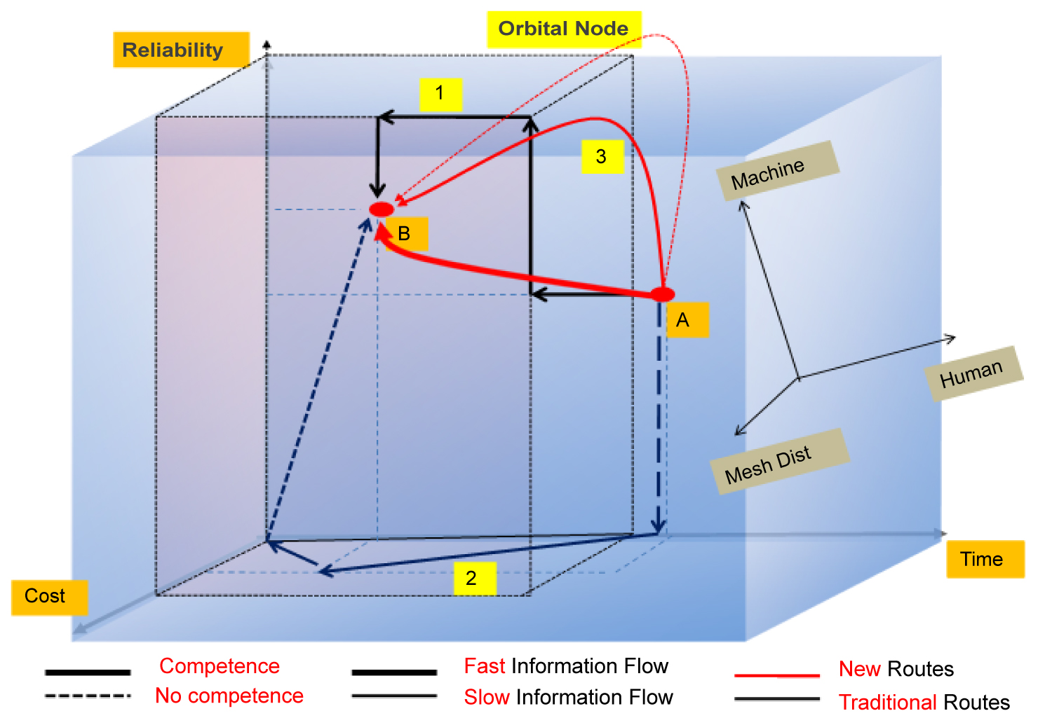
The new environment will be different from traditional ones, where information flow will not move linearly, but in any other possible way (e.g. logarithmically, hyperbolically, parabolically). On our first impression schema (Figure 2) traditional orbital environment (human machine interaction on a simple decision making process) is being represented with the outer cube whereas the inner cube belongs to the new AI model.
In order to "fly" from the outer to the inner cube an AI model will be implemented. Orbital nodes and artificial intelligence will play an important role. Today movement is being performed through the edges of the cube following a logical path with rectangular way of thinking (black arrows indicate possible routes 1 and 2 of traditional decision making mesh networking). By adding artificial intelligence and levels of dynamic capabilities to the system [1] new ways may arise (red paths). Thick and solid red lines indicates an applied orbital node hierarchy, whereas intermittent indicate that no level is in place. There may be numerous other ways of moving from the outer to the inner cube, we are just representing only some fictitious ones. All of those parameters will be inserted to the designed algorithm and tested.
Initially, multilinear analysis and regression using weight criteria must be applied. After acquiring the first results information flow must be quantified giving us the so-called initial competence level of the system, using the following formula:
Where, C = system competence level of the system, wi = criteria weight, A = criterion average and n = number of total criteria.
The above first quantification approach should start with multidisciplinary analysis of all collected factors that could potentially influence the whole system. For that reason, a set of code experiments must be performed in order to fulfill the above intriguing task.
Then 4 to 6 picosatellites will be manufactured and placed on the test bed. Measurements will be performed using the pilot algorithm. When algorithm/model is mature enough 2 picosatellites will be placed on orbit in order to support CENETIX NPS's lab field experiments and acquire real metrics. To a second extend, these measurements have to be analyzed accurately to further diligently represent the maritime superiority AI orbital system. Orbital AI model is meant to be the only solution to overcome traditional way of thinking and add more capabilities to a maritime superiority system achieving maritime governance.
The above model depicted in Figure 1 and Figure 2 can be used from governments or international organizations to enhance maritime control ameliorating already existed methods. Problems like illegal trafficking, illegal fishing, counter narcotics, counter weapons of mass destruction, protection of critical infrastructure and generally maritime security issues can be drastically solved through this proposed system. Commercial applications will also be effective, such as analysis of satellite imagery, effective control of shipping through oceans, censoring earth applications through space and saving time and cost. Artificial intelligence through space in conjunction with land applications will be the only way to our future [18].
References
- Alex Bordetsky (2000) Celestial data routing network. In: Brian J. Horais and Robert J. Twiggs, Proceedings of SPIE, Bellingham, WA.
- Alex Bordetsky, Stephen Benson, Wayne P Hughes (2016) Hiding comms in plain sight. SIGNAL magazine, AFCEA.
- Daniela Girimonte, Dario Izzo (2007) Artificial intelligence for space applications. European Space Agency, Advanced Concepts Team, ESTEC.
- Vlatko Becanovic, Ulrik Eklund, Sven Grahn, et al. (1999) HUGIN: A small satellite trying to be intelligent. Proc. SPIE 3728.
- Steven Businger, Steven R Chiswell, Michael Bevis, et al. (1996) The promise of GPS in atmospheric monitoring. Bulletin of the American Meteorological Society 77.
- G Mantzouris, A Bordetsky (2011) Modeling of picosatellite network applications to maritime interdiction operations. 2nd International Conference on Space Technology.
- G Mantzouris, Periklis Papadopoulos, N Nikitakos, et al. (2015) Exploring the application of picosatellites data for maritime security. Topic 4: Experimentation, metrics, and analysis. 20th ICCRTS.
- L Summerer, ESA Advanced Concepts Team (2013) Thinking tomorrow’s space - research trends of ESA advanced concepts team 2002-2012. 2013 IAA, Published by Elsevier Ltd.
- A Filippou, D Karras (2013) Introducing Intelligent Agents Potential into a competent Integral Multi-Agent Sensor Network Simulation Architecture Design. Scientific Research, Journal of Software Engineering and Applications 6: 42-48.
- Patrick Lambrix, Eero Hyvönen, Eva Blomqvist, et al. (2014) Knowledge engineering and knowledge management. EKAW 2014 Satellite Events, Linkoping, Sweden.
- Martin Homola, Theodore Patkos (2015) Different types of conflicting knowledge in AmI environments. Comenius Springer International Publishing, Switzerland, 52-63.
- Chiew Jingyi (2015) Modeling of Picosatellite constellation based network and effects on quality of service. Naval Postgraduate School, NPS Thesis.
- Nissen M, Bordetsky A (2011) Leveraging mobile network technologies to accelerate tacit knowledge flows across organizations and distances. Technology and Knowledge Flow.
- A Bordetsky, NPS, G Mantzouris (2011) Modeling of picosatellite network applications to maritime interdiction operations. 16th International Command & Control Research & Technology Symposium, Quebec, Canada.
- Atijosan A, Badru R, Babalogbon A, et al. (2016) Classification of medium resolution satellite imageries using artificial neural networks and swarm intelligence. International Journal of Hybrid Technology 9: 215-228.
- Xian-Zong Bai, Lei Chen, Yan-Gang Liang, et al. (2017) Orbital data applications for space objects, conjunction assessment and situation analysis. National University of Defense Technology, China.
- Yaniv Altshuler, Pentland, Alex, Bruckstein, Alfred M (2017) Swarms and network intelligence in search. Springer Publishing.
- https://spire.com
- Georgios Mantzouris, Periklis Papadopoulos, Nikitas Nikitakos, et al. (2015) Picosatellites for maritime security applications - the lambdasat case. Journal of Aerospace Technology and Management (JATM) 7: 551.
Corresponding Author
Georgios Mantzouris, Department Shipping Trade and Transport, University of the Aegean, Greece; US Naval Postgraduate School, Center for Network Innovation and Experimentation (CENETIX), 589 Dyer Road, Room 225, Monterey, CA 93943, USA, Tel: (831)-656-2287, Fax: (831)-656-3679
Copyright
© 2020 Mantzouris G, et al. This is an open-access article distributed under the terms of the Creative Commons Attribution License, which permits unrestricted use, distribution, and reproduction in any medium, provided the original author and source are credited.