

Long-Term Vegetation Changes in the Pietersburg Plateau Bushveld of the Limpopo Province, South Africa: A New Floristic Assessment of the Turfloop Nature Reserve
Abstract
A floristic assessment of the Turfloop Nature Reserve was undertaken, with specific reference to the vegetation structure, species of conservation importance (i.e. Red Data species, protected, endemic species, species of medicinal value and biotic and a biotic environment). Relevés were compiled in 33 random sample plots placed in the study area. A TWINSPAN classification, refined by Braun-Blanquet procedures, revealed eight plant communities. A hierarchical classification, description and ecological interpretation of plant communities are presented. The general structure in terms of growth forms and dominant species of vegetation has changed, compared to a similar survey conducted 39 years ago. Three new plant communities occur and changes also occurred within existing communities. The abundance of vegetation on certain areas has decreased due to severe unsustainable exploitation of resources by surrounding villages, leading to the demise of old and the establishment of new plant communities. The study addresses the long-term changes in vegetation, including the effect of human intervention. It has implications for all involved in veld management, illustrating the effects of over-exploitation on natural resources.
Keywords
Long term vegetation change, Turfloop nature reserve, Veld management
Introduction
South Africa has one of the world's greatest diversity of plant and animal species contained within one country, and is home to many indigenous species [1]. Terrestrial resources are, however, rapidly disappearing, due to conversion of natural habitat for farmland, forestry, human settlement and industrial development [2]. Some species are under threat from over-collection for medicinal, ornamental and horticultural purposes [3].
Fortunately South Africa's system of terrestrial protected areas is well-developed, and it is in such areas that biodiversity conservation has been focused. However, many of the existing protected areas are small, often isolated from one another, and separated by large areas of transformed land. Aggravating this situation is the fact that protected areas have been managed as islands of biodiversity rather than as part of a holistic land-use policy. Of concern is the fact that the existing system has arisen through a largely ad hoc process, rather than being part of a deliberate conservation strategy [4].
Limpopo DFED (2004) noted that conserved areas are important in providing protection against habitat loss for biodiversity and ecological systems. Despite having an intrinsic value, terrestrial ecosystems are important for the continued well-being of all inhabitants in the Limpopo Province of South Africa, in particular for rural populations, which require more natural resources to survive. In light of this, it is essential to ensure that terrestrial ecosystems are assessed, continuously monitored and management plans put in place to prevent adverse effects.
The Turfloop Nature Reserve (TNR) is one of 43 protected areas situated in the Limpopo Province. This protected area is surrounded by under-developed rural land, where high levels of poverty (70%) has lead adjoining residents to obtain resources (firewood and grazing) illegally from the reserve. This has resulted in a general deterioration of the vegetation [5].
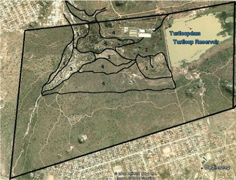
Up till 2014, the only phytosociological information available for the TNR was a single survey of Bredenkamp and Van Vuuren [6] (Figure 1). This lack of up-to-date information has resulted in an absence of appropriate environmental and ecological management plans for the TNR, which have contributed to a decline in the condition of the vegetation. Thus, a follow-up floristic assessment of the TNR was undertaken in 2014 to determine if vegetation changes occurred during the past 39 years, comparing it to results published by Bredenkamp and Van Vuuren [6].
Research methods and Design
Study area
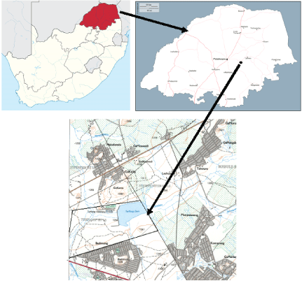
The TNR is located 35 km east of Polokwane in the Limpopo Province (Figure 2) along the R71 road (coordinates: 23°53'33.06"S, 29°45'46.29"E), 1312 m above sea level. It is bordered by the University of Limpopo on the west, the R71 road (linking Polokwane and Tzaneen) and Badimong village to the south, Ga-Kama village to its north and communal land to the east. The reserve is 550 ha in size, which includes an estimated 50 ha of granite hills, and the Turfloop dam, which is fed by the Pou River, a seasonal creek.
The TNR varies in geology which includes basement granite and gneiss, clastic sediments of the Pretoria Group (Vaalian) and ultramafic and mafic metavolcanics of the Pietersburg Group (Swazian). Shallow and skeletal soils (including Mispah and Glenrosa soil forms) occur (Soil Classification Working Group, 1991) [7]. Land Types are mainly Ib and Fa [8]. According to Dlomu [9], great diurnal variations of temperature have favoured the weathering of the granite into large boulders associated with fine sandy materials. The grey ferruginous lateritic soils are shallow and spread over the old granitic rock. Colluvial soils are found around the granitic outcrops, while alluvial soils are found in the river valley.
The mean annual rainfall of the reserve varies between 400 mm and 600 mm (with a mean of 500 mm). Rainfall is erratic, with most rain occurring in the form of late afternoon thunderstorms. Summer minimum temperatures are relatively high, exceeding 13 ℃. Winter minimum temperatures can be cold (0.6 ℃) with a mean summer temperature of 27 ℃ and a mean winter temperature of 18 ℃. Incidences of frost occur (on average 8 days per year). Mean annual potential evaporation is between 2092 and 2122 mm (SA Weather Service, 2015) [10].
The vegetation of the area within which TNR falls, belongs to the Savanna Biome. According to Low and Rebelo [8], the TNR falls broadly within the Sourish Mixed Bushveld, situated on the margin of the Polokwane Plateau Bushveld. The TNR is composed of elements of two overlapping vegetation types. These include the Polokwane Plateau Bushveld and the Mamabolo Mountain Bushveld. The Polokwane Plateau Bushveld varies from a dense, short Bushveld to an open tree savanna with a well-developed grass layer [11]. They distinguished the Mamabolo Mountain Bushveld as a subsection of the Polokwane Plateau Bushveld. The Mamabolo Mountain Bushveld consists of a combination of dense shrubby thickets and small trees of both Acacia (Senegalia, however, for ease of comparison to Bredenkmap and Van Vuuren 1977 [6], this paper will stick to Acacia) and broad-leaved species [3]. The rock slabs or domes are sparsely vegetated, and then mostly with a mixture of xerophytes, with several succulents [8].
Bredenkamp and Van Vuuren [6] the vegetation of the Turfloop Nature Reserve was classified by means of the Braun-Blanquet method. Differences in vegetation were associated with differences in topography and various soil properties. The following five plant communities were identified (Figure 1).
1. Pioneer Scirpus triqueter Wetland community in the permanent streams directly below the dam wall.
2. Pragmatism australis Reed community in the seasonally flooded wetland below the dam wall.
3. Acacia Karoo Riverine communities:
a) Acacia karroo - Ziziphus mucronata Thickets along the stream banks.
b) Acacia karroo - Sporobolus africanus Savanna on the clay soil adjacent to the stream banks.
4. Acacia tortilis Savanna communities of the undulating drier areas surrounding the wetland.
a) Acacia tortilis - Spirostachys africana Savanna of the south facing slopes.
b) Acacia tortilis - Euclea crispa Savanna of the north-east facing slopes.
According to Bredenkamp and Van Vuuren [6], the most conspicuous feature of the study area was the poor vegetation condition of the veld. This condition was due to mismanagement and misuse, especially overgrazing and trampling by cattle and goats of the local population. Bredenkamp and Van Vuuren [6] concluded that the vegetation, especially the herbaceous layer, would change under better management regimes. These changes would probably not affect the classification, but the floristic composition and the relative abundance of the different species present in the herbaceous layer would probably change.
Procedures
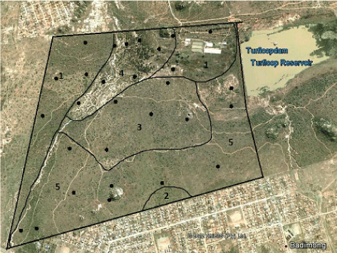
A total of 18 vegetation types (ecological units) were identified in 2014 from the most recent aerial micrograph (1997) taken of the reserve. In addition 1:50000 topographical maps and 1:10000 orthophotos were used to delineate specific areas of uniform vegetation structure. Two sample plots were randomly laid out in each vegetation type, resulting in 33 sample plots. Ground truthing was done to verify the placement of the vegetation types and the plots. These sample plots were not in the same location as those of Bredenkamp and Van Vuuren [6], as the locality of the 1977 plots are unknown.
Plot sizes varied from 100 m2 for herbaceous vegetation (Euphorbia ingens and Eragrostis rigidior Communities) to 200 m2 for dense woody (Acacia-dominated Communities) vegetation, according to the method of Rogers [12]. In order to include a realistic representation of the floristic composition and vegetation in riverine areas, the sample plots were enlarged to a 400 m2 belt. A list of all plant species occurring in a plot was made and a cover abundance value allocated to species, according to Braun Blanquet cover scales [13].
Environmental data included slope inclination measured in degrees, topography including hills, slopes and crests, aspect (north, south, west, east and aspects in between) and disturbance factors such as exotic vegetation, trampling and erosion. Information on geology, land type, soil series, and clay content were obtained from Land Type Survey Staff [14]. The computer programme TURBOVEG [15] and the TWINSPAN classification program [16] were used to capture and analyse present the data. Further subjective refinements were achieved by repositioning of species and relevés, using MEGATAB [17].
The phytosociological table of the vegetation of the Turfloop Nature Reserve, as surveyed during 2014, is presented in Table 1.
Acacia karroo Community
The community (Figure 3) is situated on a 4% north west-facing slope, comprising dark reddish brown soils. This community is a fairly open (1-10%, according to the structural classification of Edwards 1983) [18], abundantly vegetated with many large trees and shrubs. The tree stratum has relatively high species richness. The dominant species is Acacia karroo. Other conspicuous trees are Acacia tortilis and A. hebeclada subsp. hebeclada. Average height varies between 3.0 and 3.5 m. Patches of forbs and grasses are found in depressions. Shrubs are on average 0.8 m high and the herbaceous layer 0.4 m. Less than 25% of the area is not vegetated. The community has less than 2% litter and a canopy cover of 75%. The tree stratum contributes approximately 30% to canopy cover, the shrub approximately 6%, and the herbaceous layer 10%. The community is represented by seven relevés in which an average of 13 species was recorded. Associated trees include Acacia tortilis, Aloe marlothii, Euclea crispa, Gymnosporia buxifolia and Maytenus senegalensis. Shrubs are represented by Asparagus africanus, Lantana rugosa and Lippia javanica. Forbs include Tagetes minuta, Cucumis zeyheri, Bidens pilosa and Schkuhria pinnata and grasses Aristida congesta subsp. congesta, Eragrostis rigidior, Panicum maximum and Themeda triandra. The Acacia karroo community is represented by two sub-communities, namely the Acacia karroo - Chloris gayana and Acacia karroo- Aristida congesta sub-communities. The area borders the Acacia tortilis community.
Acacia karroo - Chloris gayana sub-community
This Sub-community is situated on north-facing slope with an averaged gradient of 3%, comprising dark reddish brown soils. It is densely vegetated with shrubs. Less than 10% of the area is unpopulated. The tree stratum has relatively low species richness, with Acacia karroo being the most conspicuous at 4 m in height. This Sub-community is represented by shrubs with an average height of 1.3 m and an herbaceous layer with an average height of 1.0 m. The area has less than 1% litter and a total canopy cover of approximately 90%. The tree stratum contributes 10% to canopy cover, the shrub stratum 15% and the herbaceous layer 65%. The Sub-community is represented by five relevés in which an average of 16 species was recorded. The diagnostic tree is Acacia karroo. Shrubs include Asparagus africanus and Lippia javanica. Associated forbs include Bidens pilosa, Cucumis zeyheri and Tagetes minuta, with the associated grass represented by Panicum maximum. The area is bordered by the Acacia robusta and Acacia tortilis communities.
Acacia karroo - Phragmites australis variant
The community is situated on a north-facing slope with an averaged gradient of 2%, comprising a grey clay soil. This community covers most of the vlei (marsh) area below the Turfloop Dam wall. This area is seasonally flooded and normally under water from December to May. The topography is disturbed by a number of man-made furrows. Less than 5% of the area is unpopulated. This community is densely vegetated. Trees are absent. Grasses consist exclusively of reed species. Although the community has a high abundance of pioneer species, much of the area has reached climax status. Phragmites australis, the dominant climax species, has an average height of between 2.0 and 2.5 m. Cyperus sexangularis is the second most dominant species. A plantation of Eucalyptus perriniana, an invasive species, borders the community on one side. The community has a total canopy cover of approximately 95%. The associated shrub is Asparagus africanus. Associated forbs include Acrotome inflata, Achyranthes aspera, Bidens pilosa, Cucumis zeyheri, Tagetes minuta and Xanthium strumarium. Digitaria eriantha and Chloris gayana are associated grasses.
Acacia karroo - Aristida congesta sub-community
The Sub-community is situated on a north-facing slope with an averaged gradient of 5%, comprising dark reddish brown soils. This Sub-community is sparsely vegetated (0.1-1.0%, according to Edwards, 1983) [18]. Less than 35% of the area is unpopulated and have bare soil. The tree stratum has low species richness, with Acacia karroo being the most conspicuous at 3.0 m in height. This community is represented by shrubs with an average height of 0.6 m. The herbaceous layer has an average height of 0.5 m. This Sub-community has less than 5% litter. It has a total canopy cover of approximately 65% of which the tree stratum contributes 20%, shrubs 5% and the herbaceous layer 40%. The Sub-community is represented by eight relevés in which an average of 19 species was recorded. The diagnostic tree is Acacia karroo. The shrub stratum includes the common species Terminalia prunioides. The associated forbs include Tagetes minuta, Acrotome inflata, Schkuhria pinnata. Diagnostic grasses and sedges include Phragmites australis and Cyperus senegalenses, while associated grasses are represented by Digitaria eriantha, Sporobolus africanus and Eragrostis congesta. The area is bordered by the Acacia tortilis and Acacia robusta communities.
Acacia karroo - panicum maximum variant
The variant is situated on a north-facing slope of 3% gradient, consisting of dark reddish sandy soils. This community is densely vegetated with big trees and shrubs. Less than 20% of the area is unpopulated. The tree stratum has relatively high species richness. Trees are abundant and large with the most conspicuous being Acacia karroo and A. hebeclada subsp. hebeclada with an average height of 3 to 5 m. patches of forbs and grasses are found in slight indentations on the soil surface. Shrubs have an average height of 1.5 m. The herbaceous layer is on average 0.35 m high. Panicum maximum is a dominant grass species. The Acacia karroo - Panicum maximum Variant has less than one percent litter and a total canopy cover of approximately 80%. The tree stratum contributes 30% to the total canopy cover, and the shrub and herbaceous layer 10% each. The community is represented by three relevés in which an average of nine species each was recorded. The associated trees are Acacia hebeclada subsp. hebeclada, A. tortilis, Aloe marlothii and Gymnosporia buxifolia. Dicerocaryum eriocarpum is an associated forb. The following are associated shrubs: Lippia javanica and Asparagus africanus. Eragrostis rigidior and Sporobolus africanus are associated grasses. The area is surrounded by the Acacia tortilis and Acacia robusta community.
Euphorbia ingens Community
This community represents the Mamabolo Mountain Bushveld. The community is situated on a 50% gradient north facing-slope, consisting of dark reddish sandy soils. It is densely vegetated with a large number of big trees and shrubs. Less than 35% of the area is unpopulated. The community has a low tree and shrub richness. The dominant tree is Euphorbia ingens. Another conspicuous species is Aloe marlothii, with an average height of 7 m. This community is represented by shrubs with an average height of 1 m and an herbaceous component which is on average 0.5 m high. Patches of forbs and grasses are found in depressions in the topography. This community has less than 2% litter and a total canopy cover of about 36%. The tree stratum covers of 25%, shrubs 7% and the herbaceous component 4%. The community is represented by two relevés in which average of nine species each was recorded. Associated trees include Acacia karroo, A. tortilis, Aloe marlothii, Combretum molle, Croton gratissimus, Carissa bispinosa, Ficus thonningii, Maytenus undata and Searsia leptodictya. Associated shrubs include Asparagus africanus, Euclea crispa and Vangueria infausta, while forbs include Acrotome inflata, Crassula sarcocaulis, Schkuhria pinnata, and Vernonia fastigiata. Associated grasses include Eragrostis congesta, E. curvula, E. gummiflua, Panicum maximum, Pogonarthria squarrosa, Themeda triandra and Sporobolus africanus. The area borders the Acacia tortilis community.
Eragrostis rigidior Community
This sub-community is situated on a 4% gradient, north-facing slope, consisting of dark reddish, sandy soils. This community is densely vegetated by large trees and shrubs. The tree stratum has relatively high species richness, the most conspicuous trees being Acacia karroo and A. hebeclada subsp. hebeclada, with an average height of 3.0 to 3.5 m. Panicum maximum is a dominant grass species. Shrubs have an average height of 1.0 m and the herbaceous component an average height of 0.25 m. Patches of forbs and grasses are found in depressions. Less than 20% of the area is unpopulated. The Eragrostis rigidior community has less than 1% of litter. The community has a total average canopy cover of about 80%. The tree stratum has a canopy cover of about 30%, with shrubs and the herbaceous layer covering approximately 5% each. The community is represented by six relevés with an average of 18 species each. Associated trees include Acacia hebeclada subsp. hebeclada, A. tortilis, Aloe marlothii and Gymnosporia buxifolia. Associated shrubs include Lippia javanica and Asparagus africanus, while Panicum maximum, Pogonarthria squarrosa and Themeda triandra are associated grass species. The area is bordered by the Acacia robusta and Acacia tortilis communities.
Acacia robusta Community
The community is situated on a 3% North West facing gradient, composed of dark clay to loamy soils, at an altitude of 1272 m above sea level. This community is densely vegetated with many shrubs and large trees. Less than 30% of the area is unpopulated. The dominant tree is Acacia robusta. The tree stratum has high species diversity, with Acacia species being the most conspicuous at heights 4.0 m. This community is represented by shrubs with an average height of 1.0 m and a herbaceous layer with an average height of 0.8 m. Patches of forbs and grasses are found in depressions. The Acacia robusta community has less than 1% of litter. The community has a total canopy cover of about 56%. The tree stratum contributes 50% to canopy cover, the shrubs 1% and the herbaceous layer 5%. The dominant shrub is Asparagus africanus. The associated forbs include Bidens pilosa, Cucumis zeyheri and Tagetes minuta, while associated grasses are represented by Eragrostis curvula and Aristida congesta subsp. congesta. The area is bordered by the Acacia karroo Community.
The Acacia tortilis - Pogonarthria squarrosa Community
The community is situated on a north-facing slope with an average gradient of 4%. A dark reddish sandy soil is present. This community is densely vegetated with numerous large trees and shrubs. Less than 25% of the area is unpopulated. The dominant tree is Acacia tortilis subsp. heteracantha. The tree stratum has relatively tall species, with Acacia karroo and A. hebeclada subsp. hebeclada conspicuous. Average heights are between 3.0 and 5.0 m. Pogonarthria squarrosa occurs frequently. This community is represented by a shrub stratum with an average height of 1.7 m, and a herbaceous stratum with an average height of 0.3 m. Patches of forbs and grasses occur in the slight indentations of the topography. The Acacia tortilis - Pogonarthria squarrosa community has less than 1% of litter. The community has a total canopy cover of about 75%, with the tree and shrubs each contributing 30% to canopy cover. The herbaceous component has a canopy cover of 15%. The community is represented by eight relevés in which an average of 13 species was recorded. Associated trees include Acacia tortilis subsp. heteracantha, A. karroo, A. robusta, Aloe marlothii, Gymnosporia buxifolia and Grewia flava. Lippia javanica and Lantana rugosa are associated shrubs. The herbaceous component consists of the following associated species: Bidens pilosa, Cucumis zeyheri, Dicerocaryum eriocarpum, Schkuhria pinnata, Senecio barbertonicus, Tagetes minuta and Vernonia fastigiata. Eragrostis curvula, Panicum maximum, Pogonarthria squarrosa and Melinis repens are associated grass species. The area is bordered by the Acacia karroo community.
Acacia tortilis - Pogonarthria squarrosa - Lippia javanica Sub-community
This Sub-community is situated on north-facing slope with an averaged gradient of 3%, comprising dark reddish sandy soils. This Sub-community is densely vegetated with shrubs, forbs and grasses. Less than 10% of the area is unpopulated. The tree stratum has relatively low species richness, with Acacia tortilis subsp. heteracantha being the most conspicuous at 2.0 m in height. This Sub-community is represented by shrubs with an average height of 0.8 m and an herbaceous layer with an average height of 0.4 m. The Acacia tortilis - Pogonarthria squarrosa - Lippia javanica Sub-community has less than 1% of litter. The Sub-community has a total canopy cover of approximately 90%. The tree stratum contributes 30% to canopy cover, shrubs 40% and the herbaceous layer 20%. The Sub-community is represented by five relevés in which an average of 13 species was recorded. The associated trees are Acacia tortilis subsp. heteracantha and Acacia hebeclada subsp. hebeclada. The associated shrubs include Lantana rugosa, while associated forbs include Schkuhria pinnata and Dicerocaryum eriocarpum. Related grasses are represented by Melinis repens, Eragrostis curvula, Eragrostis gummiflua, Digitaria eriantha, Panicum maximum and Pogonarthria squarrosa. The area is bordered by the Acacia karroo and Eragrostis rigidior communities.
Acacia tortilis - Pogonarthria squarrosa - Dicerocaryum eriocarpum Variant
The variant is situated on South-facing slope with an averaged gradient of 4%, comprising dark reddish sandy soils and is densely vegetated with shrubs, forbs and grasses. Less than 20% of the area is unpopulated. The tree stratum has a low species richness, with Acacia tortilis subsp. heteracantha being the most conspicuous at 2.0 m in height. This variant is represented by shrubs with an average height of 0.4 m and an herbaceous layer with an average height of 0.7 m. The variant has less than 1% of litter and a total canopy cover of about 80%. The tree stratum contributes 30% to canopy cover, shrubs stratum 10% and the herbaceous layer 40%. The variant is represented by two relevés in which an average of 10 species was recorded. The associated trees are Acacia tortilis subsp. heteracantha and Acacia hebeclada subsp. hebeclada. Associated shrubs include Lippia javanica while forbs include Schkuhria pinnata. Associated grasses are represented by Eragrostis gummiflua, Panicum maximum and Pogonarthria squarrosa. The area is bordered by the Acacia karroo and Eragrostis rigidior communities.
Acacia tortili - Pogonarthria squarrosa - Aloe marlothii Sub-community
The Sub-community is situated on the gradual north facing slopes on dark reddish sandy soils with an average slope of 18%. This Sub-community is densely vegetated with large trees and shrubs, less that 40% is unpopulated. Tree and shrub richness is, however, low, but a number of large trees occur. The dominating plant is Aloe marlothii. The most conspicuous trees are Acacia tortilis subsp. heteracantha, Acacia karroo and A. hebeclada subsp. hebeclada, with average heights of between 4.0 and 5.0 m. Shrubs are, on average, 1.0 m high. The herbaceous layer has an average height of 0.4 m. Patches of herbs and grasses found in indentations on the soil surface. The Sub-community has less than 5% litter. The tree stratum contributes 40%, shrubs 7% and the herbaceous component 2%. The Sub-community is represented by eight relevés in which average of 11 species each was recorded. Associated trees include Acacia karroo, Brachylaena rotundata, Combretum molle, Croton gratissimus, Euphorbia ingens and Ficus thonningii. Associated shrubs are represented by Asparagus africanus, Euclea crispa and Vangueria infausta. Associated forbs include Euchaetes crista galli, Rhynchosia minima, Senecio barbertonicus, Senna septemtrionalis, Thecacoris trichogyne and Vernonia fastigiata. Associated grasses include Eragrostis rigidior, E. gummiflua, Panicum maximum, Pogonarthria squarrosa and Themeda triandra. The surrounding area consists mostly of the Acacia karroo community.
Acacia tortilis - Pogonarthria squarrosa - Eragrostis gummiflua Variant
The variant is situated on north-facing slope with an averaged gradient of 5%, comprising dark reddish sandy soils. This variant is densely vegetated with shrubs, herbs and grasses. Less than 20% of the area is unpopulated. The dominant tree is Acacia tortilis subsp. heteracantha. The tree stratum has a relatively low species richness, with Searsia pyroides being the most conspicuous at 2.0 m in height. This variant is represented by shrubs with an average height of 1.0 m and herbaceous layer with an average height of 1.4 m. The Acacia tortilis - Pogonarthria squarrosa - Eragrostis gummiflua variant has less than 1% litter. The variant has a total canopy cover of about 80%. The tree stratum contributes 10%, the shrub stratum 30% and herbaceous layer 40% to canopy cover. The variant is represented by three relevés in which an average of 10 species was recorded. The associated tree is Acacia tortilis subsp. heteracantha. The associated shrubs include species such as Lantana rugosa and Lippia javanica. Associated forbs include Bidens pilosa and Schkuhria pinnata, while associated grasses are represented by Melinis repens, Eragrostis curvula, Cynodon dactylon, Digitaria eriantha and Pogonarthria squarrosa. Setaria sephacelata, Waltheria indica and Zinnia peruviana also occur in numbers. The area is bordered by the Acacia karroo community.
Exotic Species
The following exotic plant species were found at the TNR: Bidens pilosa, Opuntia ficus-indica, Phragmites australis, Schkuhria pinnata, Sesbania sesban, Tagetes minuta and Xanthium strumarium. The exotic species were found in 80% of the sampled plots. Their abundance ranged from single individuals to 50% of the sample plots, respectively. Only Eucalyptus perriniana, as an invasive species, was recorded. These large trees were introduced a long time ago, to serve as a wind-break.
Rare Species
The following species were recorded as single plants in some communities, thus occurring only once in the reserve:
Acacia tortilis, Aloe marlothii, Asparagus africanus, Bidens pilosa, Cucumis zeyheri, Dicoma zeyheri, Dicerocaryum eriocarpum, Dichrostachys cinerea, Ehretia rigida, Felicia merxmuelleri, Ficus indica, Indigofera melanadenia, Kalanchoe rotundifolia, Lantana rugosa, Lippia javanica, Melinis repens, Senecio barbertonicus, Themeda triandra, Terminalia prunioides, Tagetes minuta, Schkuhria pinnata, Sida rhombifolia, Vernonia fastigiata, and Xanthium strumarium. No Red Data species were recorded on the TNR.
Discussion
The current data can be compared with the data of Bredenkamp and Van Vuuren [6]; (Figure 1) as both these studies used comparative methods on the Turfloop Nature Reserve. The general structure of vegetation on the TNR has changed markedly with the formation of a number of new plant communities. Furthermore, no community has remained the same. The abundance vegetation cover (results not shown in this paper) of on the northern side of reserve has decreased by 50% since 1977, possibly due to severe unsustainable exploitation of resources by villagers from Badimong. This village is a mere 10 metres away from the reserve fence. This led to the establishment of the Aloe marlothii Sub-community with the demise of Acacia karroo as the dominating species. Aloe marlothii is exploited only to a very limited extent by community members of the Limpopo Province, mainly by traditional healers, who use it to treat diabetes mellitus [19].
On the north-eastern side of the reserve there has been a general decline of Acacia tortilis subsp. heteracantha since 1977, due to over exploitation by villagers, and a concomitant increase of Acacia hebeclada subsp. hebeclada and A. robusta. The structure of vegetation on this side of the reserve is severely encroached, characterised by dense vegetation consisting mainly by Acacia hebeclada subsp. hebeclada and A. robusta. The prohibition of wood harvesting by TNR officials has possibly resulted in this dense vegetation.
The communities recorded by Bredenkamp and Van Vuuren [6] are still present, with the exception being the Cynodon dactylon grassveld community. However, a number of new communities were recorded in addition to those documented by Bredenkamp and Van Vuuren [6]. These include the Acacia robusta, Eragrostis rigidior, and Euphorbia ingens Communities. The introduction of these communities could be the result of anthropogenic and animal influences, climate change and soil moisture changes.
Due to changing environmental conditions (naturally or unnaturally induced), plant communities are constantly changing. On the TNR anthropogenic influences played a significant role in the establishment of new communities. Continuous harvesting of one specific species in a community often result in a different stratum, dominated by species that were previously less abundant.
In the 1977 plant community survey of the TNR, Bredenkamp and Van Vuuren [6] classified A. robusta as belonging to the Acacia tortilis community. Since then, A. robusta has come to dominate certain areas to such an extent that it now warrants its own community. Previously, A. robusta occurred as a minor entity in the A. tortilis community in 1977. However, due to over harvesting of A. tortilis subsp. heteracantha and A. karroo for firewood by villagers living adjacent to the TNR, these species have declined in their dominance of the landscape, resulting in A. robusta becoming dominant and forming its own community. As to why A. robusta is not harvested for fuel is an open question, which needs investigation.
Villagers adjacent to the TNR illegally graze their cattle on the reserve. This has led to selective overgrazing on a number of grass species, with an ultimate effect on the plant community composition. The replacement of the Acacia tortilis - Euclea crispa grassed community with the Acacia tortilis - Pogonarthria squarrosa community from the TNR since the 1977 survey of Bredenkamp and Van Vuuren [6] can most probably be attributed to the influence of grazing pressure and poor management strategies.
The influence of climate change since the 1977 survey [6] can also not be ruled out. Climate change may have an effect on species composition and abundance. On the TNR this is difficult to ascertain due to the continuous application of anthropogenic effects (grazing and harvesting of wood) compounded by the influence of game on the reserve. This aspect warrants further investigation.
The increase in abundance of Cyperus sexangularis between 1977 and 2008 in the Acacia karroo community can most probably be attributed to water seepage from the dam, resulting in an increase in soil moisture below the Turfloop Dam.
A possible reason for the occurrence of a number of shrubs, herbs and grasses in this study that were absent from the 1977 study, might be due to the removal of tree species, which removes competition between trees and grasses. This aspect needs further investigation.
Exotic Species
Exotic plant species are organisms that are introduced into habitats where they are not native, and they are responsible for habitat alteration and degradation. These exotic plants are a major cause of biological diversity loss throughout the world and can thus be considered "biological pollutants" [20].
It is evident that the abundance of exotics increased between 1977 and 2014. Anthropogenic influences, ranging from trampling and wood cutting has resulted in the formation of bare soil vulnerable to the colonization of exotics and pioneers.
Activities to eradicate exotics on the reserve were carried out until 1992 by Limpopo DFED. Exotics were manually removed and cochineal was introduced on certain species [21]. Because of the absence of reports by DFED, under whose management the TNR fall, it is uncertain if eradication procedures were still in operation from 1992 onwards.
In an effort to stop the spread of exotic species on the TNR, continuous monitoring efforts should be introduced. In order to remedy and determine extent of invasions, actions should focus on Bidens pilosa, Opuntia ficus-indica, Phragmites australis, Schkuhria pinnata, Sesbania sesban, Tagetes minuta and Xanthium strumarium. Failure to eradicate the spread of exotics will most probably result in indigenous species being outcompeted. In the long term this could possibly have a negative impact on the biodiversity of the reserve.
Conservation of Rare Species on the Turfloop Nature Reserve
Rare species are the result of the ecosystem they inhabit which might be unusual or degraded, and as such are indicators of endangered ecosystems. They assist in determining which habitats require special corrective actions. Rare species and their habitats must also be conserved, because more often than not, it is not known what critical functions they may perform, now or in the future. Essential ecosystem services may be provided. They may be reservoirs of genetic diversity that will maintain sustainable food and commodity production. They may be required for other species or ecosystems to survive climate change or disturbances such as flood, fire or disease [22].
Distribution of single plants of a species or rare species (rare is defined as species of limited occurrence within the TNR) on some of the survey communities on the TNR can be attributed to the following factors; environmental, geographical, soil disturbance, temperature, sampling inaccuracy e.g. size of the plot.
There are a number of rare species, in this study, which has reduced their abundances when compared to the findings of Bredenkamp and Van Vuuren [6]. These include: Dichrostachys cinerea, Ehretia rigida, Felicia merxmuelleri, Indigofera melanadenia, Kalanchoe rotundifolia, Lantana rugosa, Sida rhombifolia, Senecio barbertonicus, and Terminalia prunioides. Possible reasons for their decline could be inaccurate sampling and/or a variety of anthropogenic factors (wood cutting, cattle and game trampling) and/or that the reserves have not been optimally managed.
A number of solitary species were identified in the 1977 study that was not recorded in this study. These include: Acacia permixta, Bothriochloa insculpta, Blepharis sub volubilis, Clematis brachiata, Crotalaria laburnifolia, Guilleminea densa, Hypoestes triflora, Indigofera circinnata, Sida cordifolia, Verbena officinalis and Wahlenbergia denticulata. Possible reasons for their decline could include trampling via game and cattle.
Acknowledgements
The Limpopo Parks Board and the Department of Economic Development, Environment and Tourism are acknowledged for granting permits to undertake research on the TNR.
Results
Vegetation descriptsion of plant communities.
References
- Laguna E, Deltoro VI, Perez-Botella J, et al. (2004) The role of small reserves in plant conservation in a region of high diversity in eastern Spain. Biological Conservation 119: 421-426.
- Williams Vl, Victor JE, Crouch NR (2013) Red listed medicinal plants of South Africa: Status, trends, and assessment challenges. South African Journal of Botany 86: 23-35.
- Sanbi, Deat (2004) Priorities for Conservation in South Africa. Terrestrial Component. South African National Spatial Biodiversity Assessment Technical Report Vol 1.
- Department of Environmental Affairs And Tourism (Deat) (2004) National State of Environmental Report. Government Printer, Pretoria.
- Mashatole MM (2009) A floristic assessment of the Turfloop Nature Reserve. Unpublished MSc Dissertation, University of Limpopo, Mankweng, South Africa.
- Bredenkamp GJ, Van Vuuren DRJ (1977) The plant communities below Turfloop Dam. Lebowa Publication series A17, University of the North, Mankweng.
- Soil Classification Working Group (1991) Soil classification: A taxonomic system for South Africa. Memoirs of the Natural Agricultural Resources of South Africa, Department of Agricultural Development, Pretoria.
- Low AB, Rebelo A (1996) Vegetation of South Africa, Lesotho and Swaziland. Department of Environmental Affairs and Tourism, Pretoria.
- Dlomu NI (1966) Land use in the Eastern Pietersburg District. Unpublished Hons. Mini-dissertation, University of the North, Mankweng, South Africa.
- Weather Service (2015) South African.
- Mucina L, Rutherford MC, Knevel IC, et al. (2006) The vegetation of South Africa, Lesotho and Swaziland. Strelitzia 19, South Africa National Biodiversity Institute, Pretoria.
- Rogers CML (1993) A woody vegetation survey of Hwange National Park. A phytosociological synthesis of Mopane veld. Unpublished M.Sc. Dissertation, University of Pretoria, Pretoria.
- Mueller D, Ellenberg H (1974) Aims and Methods of Vegetation Ecology. John Wiley and Sons, New York.
- Land Type Survey Staff (1985) Land types of the Maps. Memoirs of the Agricultural Natural Resources of South Africa No. 10, Soil and Irrigation Research Institute, Department of Agriculture and Water Supply, Pretoria.
- Hennekens SM (1996) Turbo(veg): Software package for input, processing and presentation of phytosociological data, User's guide. University of Lancaster, United Kingdom.
- Hill MO (1979) Twinspan: A Fortran program for arranging multivariate data in an ordered Two-Way Table by classification of the individuals and attributes. Cornell University, Ithaca, New York.
- Werger MJA (1974) On concepts and techniques applied in the Zurich-Montpellier method of vegetation survey. Bothalia 11: 309-323.
- edwards D (1983) A broad-scale structural classification of vegetation for practical purposes. Bothalia 14: 705-712.
- Semenya S, Potgieter M, Erasmus L (2012) Ethnobotanical survey of medicinal plants used by Bapedi healers to treat diabetes mellitus in the Limpopo Province, South Africa. J Ethnopharmacol 141: 440-445.
- Germishuizen G, Meyer NL (2003) Plants of Southern Africa. National Botanical Institute, Pretoria.
- (1992) Turfloop Nature Reserve. Limpopo Department of Finance and Economic Development, Polokwane.
- Raven PH (1981) Biology of Plants. (3rd edn), Worth Publications, New York.
- (2012) Google Earth.
Corresponding Author
MJ Potgieter, Department of Biodiversity, University of Limpopo, Private Bag X1106, Sovenga, 0727, South Africa.
Copyright
© 2017 Potgieter MJ, et al. This is an open-access article distributed under the terms of the Creative Commons Attribution License, which permits unrestricted use, distribution, and reproduction in any medium, provided the original author and source are credited.